mapedit.addin
![]()

The goal of mapedit.addin is to simplify the creation of spatial data by wrapping the mapedit package. As you can see in the code below the mapedit package already makes the process very simple.
library(mapview)
library(mapedit)
new_spatial_data <- mapview() %>%
  editMap()
All mappedit.addin does is wrap this piece of code in an RStudio addin. This means that the process of creating spatial data and saving it to file is completed using only GUI tools. It is also possible to link mapedit.addin to keyboard shortcuts, further simplifying the process (see here).
Installation
You can install the current version of mapedit.addin from Github with:
devtools::install_github("mrjoh3/mapedit.addin")Usage
This simple addin allows you to interactively create an sf spatial object that can then be saved and used in your code. To use, just open the addin add some geometry to the map and click Done when completed.
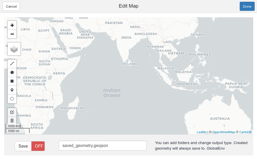
mapedit addin
Selecting text within the RStudio IDE will modify the behavior of the addin. Where no text is selected the addin will save an sf object called geom into .GlobalEnv. To save a spatial object to file, the Save switch must be toggled using the addin interface. A file called saved_geometry.geojson will be created in the current working directory. If text is selected in RStudio this will be used for naming both the sf object and the created file.
Adding objects to the map
If the text selected in RStudio IDE is the name of an existing sf object then the addin will add this object to the mapedit map and zoom to its bounds. When a spatial object is passed to the map in this way, any new geometry is added to it using rbind. It is not currently possible to edit existing geometry.
Saving to File
Spatial objects are saved to file using sf::write_sf. File names can be set by selecting text inside RStudio or via the naming bar at the bottom of the addin. The file naming bar can also be used to add file paths and to change output extensions.

image bar
The text seen in the naming bar is passed directly to write_sf. Most file drivers will be guessed by the extension. See sf::st_drivers() or OGR formats for details; only .geojson and .shp have been tested.
Note that the function write_sf is called with options delete_layer = TRUE and delete_dsn = TRUE. This means that existing files with the same name are over-written.
Future
Future updates will give the user more control over:
- the starting point of the map (currently zooms to world or input object)
- the name of output object (completed)
- file name (completed)
- add more option when saving to file
- edit existing geometry